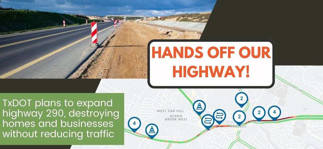
 TxDOT is planning to widen US Highway 290 from Oak Hill through Dripping Springs from its current undivided four lane format to a divided six-lane with adjacent two-lane frontage roads. To do this, TxDOT will have to widen the right of way from ~180' to ~320', forcing the destruction of 13 residences, 82 commercial businesses and one church. The current safety standards TxDOT refers to suggest a minimum right of way of 400'; in order to cinch in to minimize the amount of eminent domain claims, TxDOT will be utilizing concrete barriers as a safety measure as a result of the limited space. Downtown Dripping Springs, from Roger Hanks Parkway to Rob Shelton Blvd will be a six-lane divided highway with a concrete barricade. While we agree that vehicular and pedestrian safety should be a priority, we are not confident that this expansion proposal will solve these problems. To end a six-lane highway with frontage roads into the series of traditional four-way stop lights in downtown Dripping will not improve any traffic congestion, while adding a significant amount of impervious cover, increasing the risk of damage from floods. As stated in the feasibility draft provided by TxDOT, this breakout section would not increase the level of service rating applied to this part of the highway. Per the report: most of US 290 in Dripping Springs is forecasted to operate at a Level of Service (LOS, rated A through F) of E or worse for either the improved or no-build conditions. This proposal will also impact the migration of wildlife throughout the area, increase light and sound pollution, and impact access to the businesses that will remain along the corridor. Limited access entrance roads enter the highway in 2 mile increments, meaning local drivers will spend more time on the road, navigating turnarounds of up to 2 miles that used to be accessible via left turn lanes. More time on the road translates into more exhaust and heat pollution, and more TRAFFIC, negating any slight time improvements due to removing a few of the traffic lights. With the proposed widening, and concrete barriers, local wildlife movement will be impacted. Lack of wildlife crossings presents both a safety hazard and an impediment to the necessary movement of species. Deer/car crashes could be better addressed through adequate crossings. The feasibility draft mentions congestion at the intersection of 12 and 290, yet plans leave the intersection foundationally identical. The only changes proposed to this intersection seem to be dedicated right turn lanes on 290, and removing one of the two left turn lanes onto westbound 290 from northbound 12 (south of the intersection). The intersection of RM 12 and Mercer street isn’t included in the schematic, and may not undergo improvement. The City of Dripping Springs traffic study from 2021 mentions significant congestion at this intersection in the introduction. It is difficult to anticipate any improvements to congestion if the proposal is to provide more lanes to these intersections without improving the intersections themselves.  The environmental constraint map presented at the public meeting was meant to show seeps and springs; it marked wells in the downtown Dripping Springs area, but neglected to identify the namesake springs of the town. These should be highlighted and featured, with public access walking trails.
Our belief is that water quality could be better addressed by using bioswales within medians to clean runoff closer to the source, utilizing taller, more deeply rooted plants which aid in both clarification and infiltration. Instead, presumably closely-mown water quality ponds are placed right along the banks of creeks, even encroaching into creek channels. During 100 year flood events, these would be inundated, negating any filtration, and allowing untreated water to infiltrate and contaminate the aquifer. Likewise, breaking up the east and west-bound lanes with interior bioswale medians reduces the chance of hydroplaning from excess runoff, creating safer driving conditions. It is curious that no alternatives to traditional four-way intersections are a part of this proposal. If this TXDOT proposal included options for roundabouts, diverging diamond interchanges, or otherwise addressed the congestion at intersections along this route, it may be possible to mitigate widening the right of way and the costs associated with that, while accomplishing improved mobility and safety for all. If, in order to maintain the highest measure of safety, it becomes necessary to further lower the speed limit along the corridor to 45mph, this may also encourage drivers to find alternative routes to and around Dripping Springs such as Fitzhugh Road or FM 1826, both of which are scheduled for improvements per their respective jurisdictions. Improving alternate routes for travelers should be a concomitant suggestion to improve traffic and safety. An important further consideration is the new 2500 student high school planned for Dripping Springs off Darden Hill Road; once constructed, this facility will greatly relieve congestion at 290 and 12, as students east of there will no longer be traveling through at busy times. It’s an interesting exercise to contemplate which takes longer, and comes at a greater cost in terms of money, environmental destruction, and lost time: a new school, or years of highway delay due to environmental and funding requirements and roadway construction? While this part of the Hill Country is experiencing unprecedented growth, it's disappointing, if not offensive, to be presented with a project that maintains the status quo for a highway layout that will continue to need improvements for as long as the infrastructure exists, while destroying the livelihood of almost 100 business owners and the homes of over a dozen more, and offering no relief from the problems mentioned by the community. To spend a quarter of a billion dollars on a project that will destroy the character and feeling of Dripping Springs while not solving the problems it set out to is an insult to everyone here. Thank you for the opportunity to review plans and submit comments. Public participation is a valuable ingredient to any public infrastructure. For those utilizing this to create their own comments, here are further references for consideration: What is Vision Zero? | Vision Zero Network Urban Street Design Guide | National Association of City Transportation Officials (nacto.org) Downtown Thoroughfare | National Association of City Transportation Officials (nacto.org) w15376.pdf (nber.org) Your participation is crucial to preserving the Hill Country and Proposing REAL solutions for our community's transit challenges. Hands Off Our Highways! SOS Alliance Comments are closed.
|
Archives
July 2024
Categories |
 RSS Feed
Save Our Springs Alliance
|
Quick Links |
SOS is a 501 c3 non profit and your donation is tax deductible